Only one player went a perfect 4-0-0 over the two days of play at the Old Course at St. Andrews.
The American dominance in the Walker Cup continues.
The Red, White and Blue came back from a three-point deficit on Sunday to win the biennial bash against Great Britain and Ireland, 14½-11½, to claim the Cup for a fourth consecutive event.
Ten players comprise each team and there are four sessions of play with Foursomes and Singles on both Saturday and Sunday. Four teams of two compete in Foursomes on both days, while eight players compete in Singles on Saturday. All ten players play Singles on Sunday.
Leading the charge for the United States was the world’s top-ranked amateur, Vanderbilt junior Gordon Sargent, who went a perfect 4-0-0 over the two days of play at the Old Course at St. Andrews. Sargent is the only player of the 20 who competed to finish the week unbeaten and was one a few who earned three out of a possible four points.
Here’s how each player fared over the weekend at the 2023 Walker Cup at the Old Course at St. Andrews.
The North Canadian River used to flood Oklahoma City. So, in the 1950s, the Corps of Engineers redirected the flow, leaving a dry ditch.
“We used to joke that we mowed the river two or three times a year,” said Mike Knopp, executive director of Riversport, a nonprofit foundation encouraging people to get active outdoors. “You stayed away from the river. It was right through the heart of town, so it did a lot to divide the community.”
But since a $53.5 million project brought back seven miles of river in 2004, the renamed Oklahoma River has become a major draw for local and international athletes. The enormous Riversport complex is at the heart of this shift. “We wanted to infuse a more active outdoor culture in OKC,” Knopp said. “We don’t have an ocean. We don’t have mountains. So we wanted to try to create these experiences.” On a hot July day, I experienced Riversport. Here are 13 adventures you can try with Riversport OKC.
Less than half an hour outside Chattanooga, Tennessee, Rock City rests upon Georgia’s Lookout Mountain. Advertised across American highways through bright red barns painted to read “See Rock City,” this destination houses a treasure trove of unforgettable landscapes. Here’s what curious tourists and prospective visitors need to know.
What is Rock City? Described as a “unique geological and botanical wonder,” Rock City blends art and nature to create a one-of-a-kind walking trail. Sightseers can traverse this 4,100-foot path through caves, gardens, rock formations, waterfalls, and more. It’s a novel way to interact with nature that appeals to tourists worldwide.
During a recent press trip with Chattanooga Tourism Co., I got to experience Rock City up close. Discover which attractions Outdoors Wire recommends with this handy Rock City visitor’s guide.
Photo by Grae Gleason
Who should visit Rock City?
Anyone who can appreciate natural beauty and art should consider visiting this destination. Rock City will especially engage outdoorsy folks and families looking for a serene yet captivating adventure.
The main route through Rock City branches into areas that best suit people who can navigate narrow walking paths, stairs, and tight squeezes. For visitors seeking a more accessible route, Rock City provides a ramp entrance that leads guests through part of the Enchanted Trail. From there, groups can reach the Lover’s Leap and Seven States Flag Court overlook.
Waterfalls, gardens, overlooks, and art
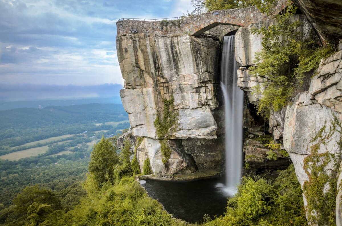
Speaking of the Lover’s Leap overlook, this part of Rock City showcases some of the spot’s most attention-grabbing sights. Lover’s Leap itself is a rock formation that sticks out from Lookout Mountain. According to Rock City’s trailside information panels, Lover’s Leap gets its name from a “Cherokee legend of two young lovers.”
As visitors approach Lover’s Leap, they’ll enjoy a lovely view of High Falls. At 140 feet tall, this waterfall is the gem of Rock City. Bring a camera to capture family pictures in front of the falls, but be prepared to wait your turn on busy summer days.
Photo by Grae Gleason
Other top attractions include Rock City’s lush gardens and scenic overlooks. Greenery thrives in the spaces between curious rock formations. During your visit, look for the little plaques labeling different vines, flowers, and trees. Labels throughout Rock City help orient visitors and inform them about the site’s most interesting landmarks.
Look out for those labels and carefully placed art installations throughout the area. Each piece builds upon Rock City’s whimsical beauty. Go on a scavenger hunt during your visit to find artworks like “Ibsen the Troll,” “Villa Aviana,” and “Perched Raptor.” Families familiar with Disney World’s “hidden Mickeys” can also keep an eye out for Rock City’s hidden gnomes.
Photo by Grae Gleason
Fairyland Caverns
Rock City is for everyone, but Fairyland Caverns and Mother Goose Village are perfect for kids (and adults with an eye for camp aesthetics). Step into this quirky and fantastical passageway to tour a collection of glow-in-the-dark fairytale scenes woven into the rocks. In 1964, sculptor Jessie Sanders completed the Mother Goose Village dioramas. Today, guests can admire their details on a trip through a dark cave.
Each display depicts either a story from European folklore or a classic nursery rhyme. Parents can challenge their kids to find their favorite figures from different fairy tales. Search for everyone from Humpty Dumpty to the Three Little Pigs.
Photo courtesy of Chattanooga Tourism Co.
Rock City seasonal events
In November and December, visitors can witness a magical holiday spectacle. For almost 30 years, the Enchanted Garden of Lights has turned Rock City into a winter wonderland. Travel through the trails to see twinkling lights, the Yule Village, and other charming holiday sights.
Rock City’s seasonal offerings don’t stop after Christmas. For St. Patrick’s Day, the destination transforms into Shamrock City. Expect Irish music, food, and beer offerings. Plus, stop by High Falls to see the water flow green. October brings Rocktoberfest, complete with fall color and German cultural celebrations. October brings Rocktoberfest, complete with fall color and German cultural celebrations. In May, nature-loving crowds will enjoy scoping out flowers during the Southern Blooms Festival. Learn about these events and more here.
Photo courtesy of Chattanooga Tourism Co.
Disclaimer: While this article was not sponsored, Outdoors Wire did visit Rock City during a press trip with Chattanooga Tourism Co. As always, Outdoors Wire operates independently, and this doesn’t influence our coverage.
A beach vacation is the perfect way to end a summer of fun. If you want to relax on a sunny shore or take a dip in cool waters, find the time to visit one of your state’s beaches.
Before the discussion starts, let’s define what a beach is. Some people think that oceanic, coastal beaches are the only real beaches. But, lucky for landlocked states, lake beaches also qualify as beaches. In fact, according to Merriam-Webster, a beach is any “shore of a body of water covered by sand, gravel, or larger rock fragments.”
With that explained, here are the best beaches in all 50 states. Pack your bag, it’s time for a summery adventure!
Sometimes, I think Flagstaff, Arizona, has shot itself in the foot with all the “gateway to the Grand Canyon” hype. At 75 miles away, it is close to that epic hole in the ground. But Flagstaff is a fun and cute city with plenty to do, and it deserves travelers’ attention as a destination, not just a place to drive through.
The city of 77,000 rests 7,000 feet above sea level — the sweet spot for ponderosa pines, which grow at 6,000 to 9,000 feet. Tree huggers will love visiting the world’s largest contiguous ponderosa pine forest surrounding Flagstaff. Since the 1960s, international athletes have used Flagstaff as a high-altitude training site. So pack your hiking boots and sporty layers, because it’s time to get outside.
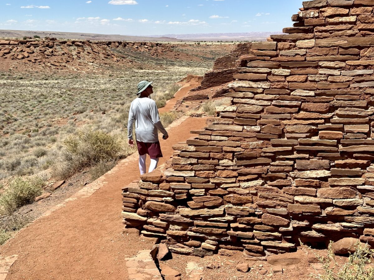
On a hot, windy day, we wandered down a short trail to Wukoki Pueblo. It’s one of several pueblo sites you can visit within Wupatki National Monument. We were only an hour from Flagstaff, Arizona, but the old dwelling felt remote.
Two park volunteers told us about the Hopi people who once lived here. “How would you like to stand in a 900-year-old tower?” one asked. We crouched down through tiny doorways — me looking carefully for rattlesnakes — then stood up at the base of a three-story tower, marveling at the people who had built this old structure out of red stones.
Photo by Teresa Bergen
Wupatki occupies 56 dry square miles of land on the southwestern Colorado Plateau. It’s connected with Sunset Crater Volcano by a 35-mile loop road, and a single entrance fee gets you into both parks.
Communities occupied the pueblos from about the 1100s. They developed ways to live despite climate extremes and scarce water. Their homes range from one-story, single-family dwellings to complicated high-rises reminiscent of condos. They were built with sandstone slabs, basalt chunks, and limestone blocks set with mortar. Amazingly, the homes are still somewhat intact 700 years after the residents left.
Wupatki Pueblo. / Photo by Teresa Bergen
The people lived on a diet of corn, squash, beans, grains, seeds, and fresh meat from hunting. Plants served medicinal, nutritional, and practical purposes. People used rabbitbrush to treat headaches and for green and yellow dyes. Hopis added saltbush wood ash to cornmeal when making bread. This provides niacin, which helps prevent protein deficiency in people who depend heavily on corn. You’ve got to wonder how people figured that one out.
Wupatki became a national monument in 1924, thanks to President Calvin Coolidge. Archeologists still debate many Wupatki topics, including their trading patterns. There’s evidence of interaction with other early people. Homes were built in an Anasazi way but included Sinagua-style textiles, pottery, and tools. A large ball court has intrigued archeologists since the 1930s. What sort of game was played here? And did the game come from the Aztecs or Mayans, who had similar ball courts?
The mysterious ball court at Wupatki Pueblo. / Photo by Teresa Bergen
Visitors can explore several different pueblo sites. The Citadel and Nalakihu pueblos are next to the main road. Getting to Wukoki Pueblo requires driving a 2.5-mile spur road. It’s a half-mile trail hike to Lomaki Pueblo. All sites, except Lomaki and Box Canyon Pueblo Trails, are at least partially wheelchair-accessible.
Come prepared. There are no gas stations, restaurants, or overnight accommodations inside the monument. Fill up your water bottles ahead of time. Bonito Campground near Sunset Crater is open from late spring through early fall. It has running water and restrooms but no showers.
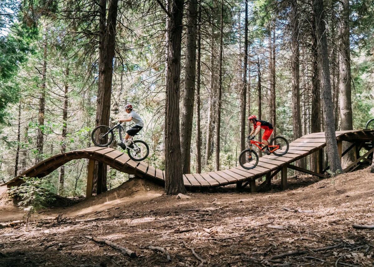
People who have lived in Southern California long enough might remember Santa’s Village, a year-round Christmas theme park that delighted children with rides and reindeer. Now, SkyPark at Santa’s Village has been revamped into a mountain biking park that delights riders of all skill levels while preserving a few touches of the North Pole.
Photo courtesy of SkyPark at Santa’s Village
When the old theme park tucked into the San Bernardino Mountains came up for sale in 2014, mountain biking couple Bill and Michelle Johnson jumped at the chance to develop their dream bike park. They envisioned a place with enough variety for a whole family, from toddlers to grandparents.
“We have a pump track for the little ones, entry and medium level trails, and even expert-level tracks that keep pro riders coming back,” Bill Johnson said in a statement. “The park is designed much like a ski resort, although we do not have a lift service. Everyone can ride together to the top, but a scaled network of trails for all levels can bring you down, back to the village, at a central location to regroup. We’re constantly improving and adjusting trails, with expansion continuing to change the experience every season.”
The park offers trails for riders of all skill levels. / Photo courtesy of SkyPark at Santa’s Village
SkyPark offers group and private lessons for ages three and up, plus an onsite bike shop. Buy a bike from SkyPark’s Bike Swap, and you’ll get a credit for a day of riding at the park. Families can camp at the campground next door or bring their RV.
Photo courtesy of SkyPark at Santa’s Village
The original Santa’s Village opened in 1955, before Disneyland. It went through a bankruptcy and a couple of owners and iterations before closing in 1998.
“Bill and I used to come here when we were younger, back when Santa’s Village was closed, and make bike paths through the trees,” Michelle Johnson said. “In 2014, long after we were married and had gained significant experience in the real estate world, we saw the old Santa’s Village property come up on the market and it was like the universe was giving us a chance to share this magical place with the world. Now everyone gets to experience the park we’ve spent years perfecting.”
Photo courtesy of SkyPark at Santa’s Village
SkyPark at Santa’s Village is part of a larger trend of using traditional skiareas for mountain biking during the off-season. “We’re proud to be a part of that mindset shift,” Bill Johnson said. “These mountains need to be experienced and mountain biking is such a great way to do it year-round. It’s good for the local community as well, to have something year-round again. Plus, we’ve brought the famous Santa’s Village theme park back to life for new generations, and that’s really special.”
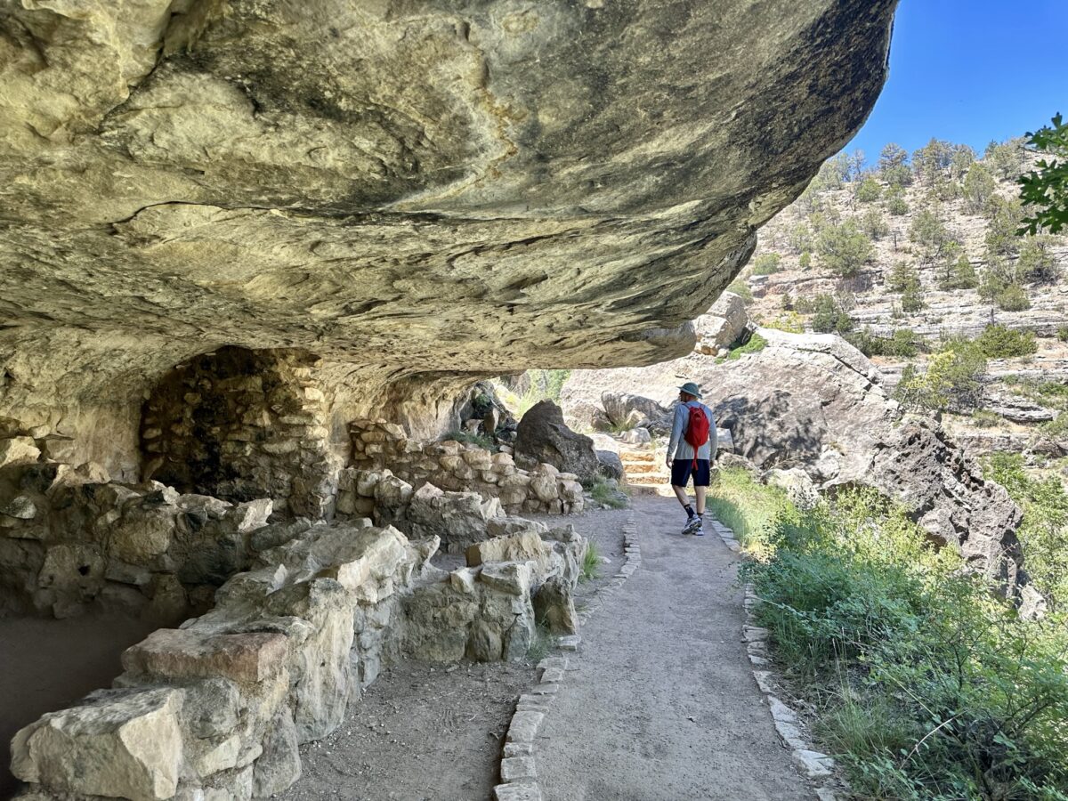
A visit to Walnut Canyon National Monument lets you imagine yourself 700 years back in time when earlier people lived in cliff dwellings with incredible views. Check out the forested canyon, the cacti, and the blue sky. You might just fantasize about living here yourself.
Cliff dwellings at Walnut Creek National Monument. / Photo by Teresa Bergen
The monument is 10 miles southeast of Flagstaff, Arizona. Archeologists refer to the 12th- and 13th-century inhabitants as Sinagua cave dwellers. But don’t mistake these folks for cavemen. People lived in a complicated and cooperative society in the canyon.
Their dwellings were very clever. They used what nature provided — back walls, floors, and leak-proof ceilings — in the rock alcoves. Then, they built thick side walls out of limestone blocks and mud, providing insulation and retaining heat in winter. They probably decorated their living spaces with rugs and hung animal skins over the small door openings facing the canyon.
Early cliff dwellers had sensational canyon views. / Photo by Teresa Bergen
Archeologists think the larger rooms were living spaces, and the smaller rooms stored water, food, and tools. They might have kept a 100-day water supply in large pottery vessels. Archeologists have recovered sandals, knives, and tools for making arrow shafts and pottery.
Walnut Creek created the surrounding 400-foot canyon. The cliff dwellings are naturally carved from Kaibab limestone. Early people added a hole to let smoke escape from their heating fires.
Smoke escaped through a hole high up in the cliff dwelling. / Photo by Teresa Bergen
On a recent visit, the site felt very peaceful and quiet (despite quite a few visitors). There was little sound except the wind and an occasional passing bird. The one-mile Island Trail — paved, with stairs and handrails — descends 185 feet into the canyon. At almost 7,000 feet in elevation, it can be a little strenuous on the way back up, especially if you’re a sea-level dweller. Hike slowly, and be sure to carry some water with you. The trail is too steep for wheelchair users, and pets aren’t allowed.
The visitor center on top is built to blend in. / Photo by Teresa Bergen
Alternatively, you could take it easy and stay on the Rim Trail above, from which you can look down into Walnut Canyon. At the top, the monument has a nice interpretive center with a good selection of Arizona books.