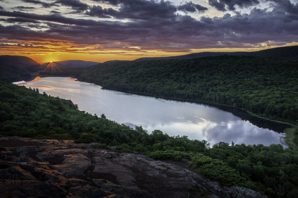
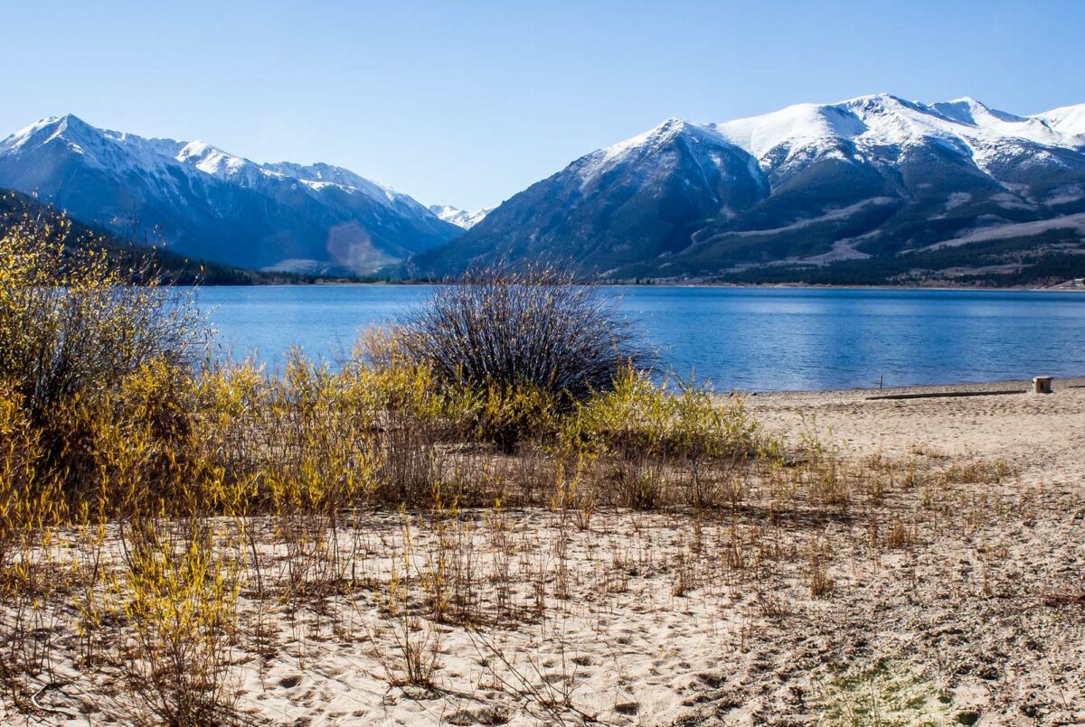
South of Michigan’s stunning Isle Royale National Park, another natural wonder calls to adventurers from all over the United States. Outdoorsy explorers, start packing your bags. It’s time to discover Porcupine Mountains Wilderness State Park.
Known as the Porkies by locals, the Porcupine Mountains are the heart and namesake of Porcupine Mountains Wilderness State Park. This roughly 60,000-acre area encompasses old-growth forest, part of the Lake Superior shoreline, waterfalls, and more. Hikers can explore more than 90 miles of hiking trails. Campers can relax in the backcountry, at established campgrounds, or in cozy cabins and yurts. Even skiers can enjoy the Porkies with help from the local winter sports complex.
Start planning your trip to Porcupine Mountains Wilderness State Park with the gallery of sightseeing locations and camping areas below.
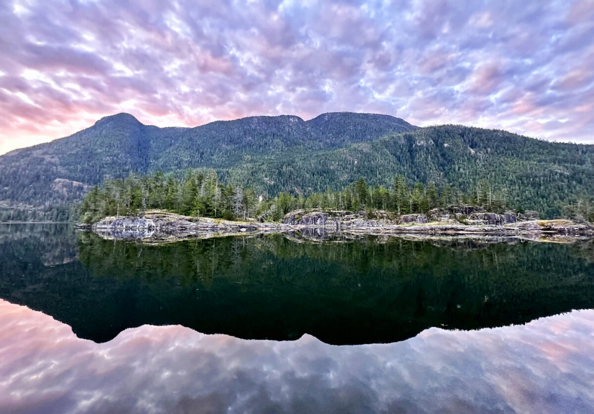
It’s 7 a.m., and six of us are looking for pictographs while cruising along Canada’s British Columbia coast on a small boat. The air is cool, and the still water reflects pines and snowy mountains.
Our guide, Greg Shea of Maple Leaf Adventures, lives on the islands off the British Columbia coast. He won’t say exactly what the red marks on the rock faces symbolize — First Nations people have different opinions about what they signify, and if anybody knows for sure, they’re not telling the general public. One looks like a fish standing on its tail. The pictographs (made with red ochre and oily fish eggs, then sealed with urine) date back perhaps 250 years.
Desolation Sound pictographs. / Photo by Teresa Bergen
Shea is a fast talker with endless knowledge of the British Columbia coast. While we ponder pictographs, he explains the Grease Trail that First Nations people developed for trading valuable eulachon (also called ooligan or candlefish) oil. They’d transport it inside the hollow tubes of bull kelp sealed with cedar corks.
“You’d put a stick across your back like this,” he demonstrates animatedly, an enthusiastic guide no matter what time of the day or night. “And then you would slide the tubes of your grease onto your stick. And you know, then they would walk. And you’d basically be going through the forest with a stick full of tubes.”
Then, he interrupts himself, saying, “Oh, a merganser!” He seamlessly slips from discussing First Nations culture to the natural world to George Vancouver’s travels and the difficulties of reading the complicated tidal patterns within Desolation Sound.
Photo by Teresa Bergen
For nature lovers who enjoy slow-paced adventures and lots of talk about trees, critters, and sea life, cruising Desolation Sound with Maple Leaf Adventures is bliss. Our group of 12 passengers and 10 crewmembers aboard the 138-foot luxury catamaran Cascadia had the extra luck of temperatures in the 60s and low 70s and no rain during our four-night springtime cruise.
What is Desolation Sound?
Desolation Sound Marine Provincial Park is well known to boaters. This area of fjords and islands lies between mainland British Columbia and about halfway up the east side of Vancouver Island. Our cruise started in the Vancouver Island town of Campbell River.
As we wound around uninhabited islands looking for wildlife, snow-capped mountains towered over us. At Desolation Sound’s most dramatic point, the peak of Mount Addenbroke rises 5,200 feet above the water. Our boat floated 2,300 feet from the bottom of the sea.
Sunrise over Desolation Sound. / Photo by Teresa Bergen
“It is very awe-inspiring,” said Emily Grubb, our boat’s naturalist. “You feel so small because there’s so much water below you and so much land above you.”
“The beautiful blue color of the water is really special to this area,” Emily Grubb, our boat’s naturalist, said. “It is very awe-inspiring in the sense that you feel so small because there’s so much water below you and so much land above you.” Add in powerful waterfalls and some black bear sightings, and you have an incredible nature break.
One of the giant, crashing waterfalls of Toba Inlet. / Photo by Teresa Bergen
During our trip, we were often the only boat visible. But the area gets crowded during summer, when boaters come for the sunny days and warm water. In certain places, Desolation Sound heats up to a swimmable 75 degrees.
Cruising, hiking, and kayaking
Our main activity was cruising around admiring the scenery, either on the Cascadia itself or the two small crafts (called tenders) that took us into places too tight for a deluxe, oversized catamaran. As we sat comfortably on the padded seats of the Auklet and Puffin, Grubb and Shea pointed out trees and wildflowers.
We were a little early for the humpback whales that visit the area in summer. But one day, a pod of graceful and glistening Dall’s porpoises played in the tender’s wake. We also saw Pacific white-sided dolphins, harbor seals, Steller and California sea lions, and two black bears. Binoculars were a must for this trip, especially for safe bear viewing.
The Cascadia carries a fleet of tandem inflatable kayaks. Twice, Grubb took four of us avid kayakers out to see the wilderness at an even more intimate level. We got right on the shoreline of the inlets, where we could see ochre sea stars and watch barnacles in action. We almost tipped our kayak, peering into the water to watch the feather-like appendages sticking out of the holes in barnacles, combing the water for edible microscopic organisms. Curious harbor seals stuck their heads out of the water to stare at us.
Photo by Teresa Bergen
We also got a good look at many seabirds. Grubb, a bird enthusiast, is always happy when people hoping to see bears and whales develop an interest in birds.
“It is kind of neat how quickly people kind of jump on the bird train,” Grubb said. “Especially when you start talking about some of their weird characteristics.” We saw plenty of her favorite sea bird, the black oystercatcher, with its long red beak.
Our group also had chances to go for short hikes in the forests of red cypress, Douglas fir, hemlock, and Sitka spruce. There, we saw remnants of 1920s logging operations. A hundred years later, we could still see the holes in gigantic stumps where loggers had driven in springboards to stand on while they worked two-person crosscut saws.
Grubb explaining old logging techniques. / Photo by Teresa Bergen
Maple Leaf Adventures’ three-ship fleet
This family-run business based in Victoria runs British Columbia and Alaska cruises on three distinctive boats. The Cascadia is by far the poshest, with a jacuzzi, spacious staterooms, and large lounging areas both inside and out. It even has a helicopter pad for winter heliskiing trips.
Guests can also choose to sail on the Maple Leaf, a 92-foot schooner built in 1904, or Swell, a 1912 tugboat. Each has a very different personality and feel.
When the helicopter is absent, Cascadia’s helipad is a perfect morning yoga spot. / Photo by Teresa Bergen
“[Guests] go onto the website and they will identify with one of three vessels,” said Shea, who frequently captains the Maple Leaf.
I initially chose the gorgeous tugboat Swell. But the dates didn’t work out, so instead, I wound up on the Cascadia. And it’s hard to argue with luxury.
“For some it’s a little bit uncomfortable on the smaller boats,” Shea told me. “Where Cascadia’s kind of bridging that and bringing that comfort to the wilderness, but also the adventure and the ability for the ship to go into remote places.”
Photo by Teresa Bergen
One of the other guests told me that she and her husband had also wanted to cruise on Swell — until they contemplated how his six-foot-plus frame would feel in the cramped confines of the tugboat.
Whichever boat guests choose, traveling with Maple Leaf Adventures is a slow tourism experience. During our five-day trip, the Cascadia only covered 132 nautical miles (151 miles for you landlubbers). Our average cruising speed was 8 knots (9.2 mph).
If you have a voracious appetite for scenery and want to enjoy watching waterfalls and bears, this trip is for you.
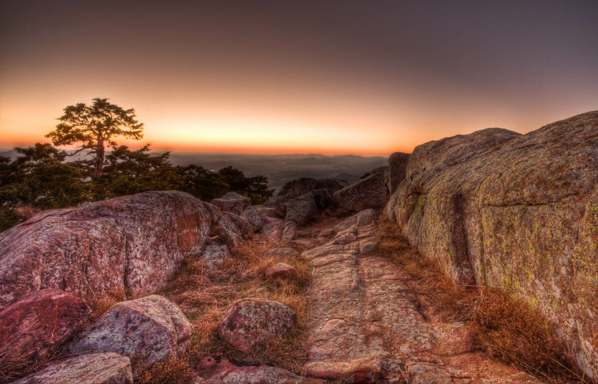
Discover the wild and wonderful landscapes of Oklahoma. On a trek through the Wichita Mountains, travelers can explore unforgettable sights. Located west of the Chickasaw Nation and southwest of Oklahoma City, the mountains soar to an elevation of 2,481 meters. For travelers seeking a quick trip through the region, the Wichita Mountains Scenic Byway offers stunning views. But tourists searching for more can find several fascinating attractions if they know where to look.
Hikers, anglers, and wildlife enthusiasts have plenty to look forward to on a trip through this area. Plan your visit with this guide to eight of the best things to see in the Wichita Mountains.
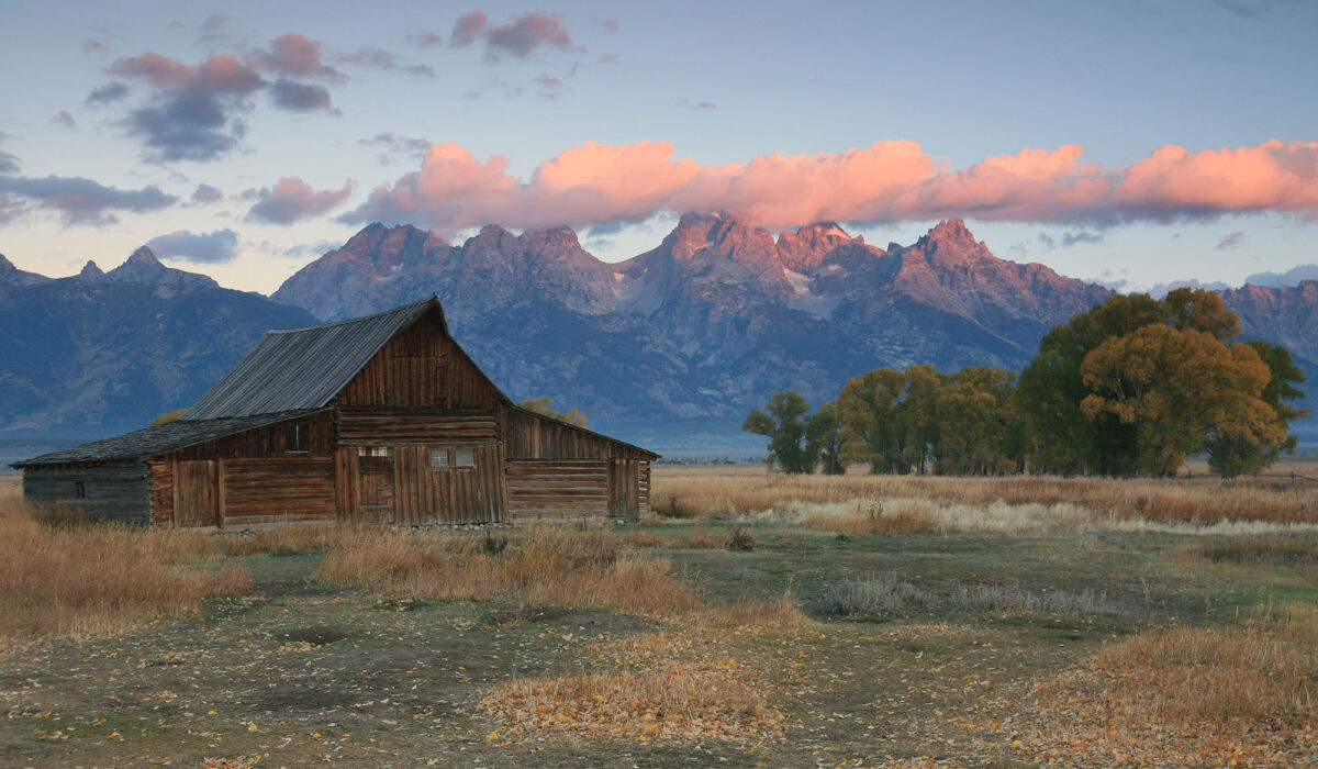
Mosey your way over to Wyoming for some of the most captivating mountain vistas in the United States. At Grand Teton National Park, tourists can expect days full of awe-inspiring nature explorations. Memorable landmarks like Oxbow Bend, Colter Bay, and more provide visitors with hours of outdoor entertainment. And while many of these places are worth visiting, guests may want to prioritize a few key regions to get the most out of a trip to the area.
Three hotspots will treat visitors to the best views of Grand Teton National Park. Below, you can peruse details on Schwabacher Landing, Jenny Lake, and the Teton Mountains. Plan your trip around the overlooks, trails, and other key points in these areas for an unforgettable experience.
Photo by D. Lehle, via NPS
Schwabacher Landing
Just minutes from the parking lot, Schwabacher Landing welcomes guests to the park with spectacular views. To reach this area, guests will hike roughly 350 yards (less than .2 miles) along a channel of the Snake River. Stop upon reaching a large beaver dam, where you can spot the animals during active hours around dawn and dusk.
Nature photographers and sightseeing tourists will enjoy some of the park’s most stunning landscapes at Schwabacher Landing. While summer and fall are popular seasons for seeing the park in full bloom, visitors who thrive in colder weather can marvel at the snow-covered Teton Mountains in winter.
NPS photo by Geoscientists-in-the-Parks
Jenny Lake
Jenny Lake is one of Grand Teton National Park’s most visited spots for a reason. This gorgeous lake sits at the base of the Teton Range and serves as the “centerpiece” of the park. While here, stop at the Jenny Lake Visitor Center inside Harrison Crandall Studio. This 1920s building was renovated in 2019 and lets guests meet with park rangers and explore art’s role in National Park Service (NPS) history.
Several scenic hiking trails lead visitors to further adventures in the Jenny Lake region. If you want to wander through nature on a long hike, follow nearby trails like Lake Solitude and Hurricane Pass. For incredible photos, take an out-and-back hike on South Jenny Lake Loop Trail to reach Inspiration Point. South Jenny Lake Loop Trail can also take hikers to Hidden Falls, where snowmelt feeds into a majestic waterfall.
Want to spend even more time near Jenny Lake? Consider booking a stay at Jenny Lake Lodge. The cozy cabins will keep you close to the park’s best views.
Photo by P. Potter, via NPS
The Teton Mountains
No trip to Grand Teton National Park is complete without exploring the Teton Range. After all, the park is named for these incredible mountains. You can’t miss this natural wonder, as the range rises above the Jackson Hole valley.
Mountaineers don’t need a permit to venture through the Teton Range. However, climbers will need a camping permit if they’re planning an overnight trip. Expect snow on the mountain until mid-July, and come prepared for surprise storms. The NPS recommends prospective climbers read books like “A Climber’s Guide to the Teton Range” and “Teton Classics” for further information on local climbing conditions.
A drive up to the mountains offers a unique sense of calm. As you climb higher, nature’s beauty unfurls all around you. Small towns nestled between stretches of untouched wilderness give these areas a serene atmosphere that helps you unwind and leave your cares behind. In the United States, regions like the Appalachian Mountains, Cascades Range, and Rocky Mountains provide tourists with tons of delightful mountain towns just waiting for a visit. When planning a mountain getaway, it can be difficult to find out which areas will best suit you. Make the process easier with this list of the best mountain towns in the U.S.
These gorgeous photos guide you through a stunning hike.
Just north of San Francisco, Mount Tamalpais State Park draws in hikers looking for an outdoor adventure. The stunning landscape offers winding trails, beautiful forests, a serene creek, and many more natural wonders. A whimsical atmosphere fills the land, from the park’s Redwood trees to its rolling hills. Visitors who explore this land will see why author Jack Kerouac paid tribute to Mount Tamalpais in his novel “The Dharma Bums.”
”See up there, as beautiful a mountain as you’ll see anywhere in the world, a beautiful shape to it, I really love Tamalpais,” Kerouac wrote.
Take a virtual hike through Mount Tamalpais State Park with these seven photos that illustrate why so many people love the area.
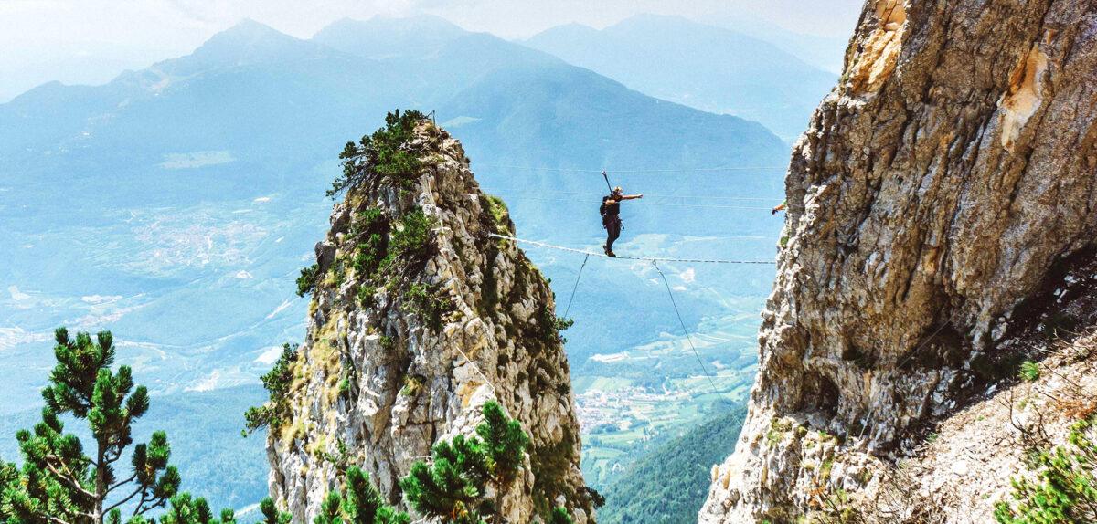
Thrillseekers, Via Ferrata Delle Aquile might be your new favorite hiking route. Also known as the Eagles’ Via Ferrata, this suspended iron path in Trento, Italy, welcomes expert hikers for the challenge of a lifetime. Located on Paganella Mountain’s eastern face in the Brenta Dolomites, the Eagles’ Via Ferrata consists of a narrow footpath that overlooks the nearby Adige Valley. Those experienced and brave enough to travel the route earn bragging rights for tackling one of Europe’s most extreme hiking locations.
Cable cars and chair lifts from Andalo and Fai della Paganella, comunes in northern Italy, help adventurers reach the area. After a drop-off at Cima Paganella, hikers walk along Eagles’ Track (Sentiero delle Aquile) to arrive at the Eagles’ Via Ferrata. Here, “expert alpinists” will don harnesses, a fall damper, carabiners, and a helmet before taking on the via ferrata.
All of this preparation leads hikers to the real challenge. Adventurers beginning their Eagles’ Via Ferrata journey will find themselves balancing on a slim, foot-shaped path. This incredible video from @tripotocommunity on Instagram shows just how gorgeous and nerve-wracking the trip can be. Of course, if one adrenaline-pumping isn’t enough, visitors can also ascend Il Volo dell’Aquila (The Flight of the Eagle), a rope stair path that twists 360 degrees.
Tricky pathways and a high point of 2,092 meters (6863.5 feet) earn Eagles’ Via Ferrata a high difficulty rating on Outdoor Active. Still, the unmatched views and experience have past guests raving about the attraction. As a final reward for hikers who explore the area, an eagle sign reading “benvenuti nel trono dell’aquila” (“welcome to the throne of the eagle”) invites visitors to take a photo to remember their trip.