The Jaguars haven’t made any plans regarding Tropical Storm Idalia, but they’re monitoring the potential hurricane as it approaches Florida.
The Jacksonville Jaguars haven’t made any plans regarding Tropical Storm Idalia, but head coach Doug Pederson said the team is monitoring the potential hurricane bearing down on Florida.
“We’ll keep an eye on it,” Pederson told reporters Monday afternoon. “Late tomorrow and into Wednesday and then all-day Wednesday we will monitor that and see where it’s going. We went through this last year with a couple of storms that came through. This one might come a little bit closer than those two did, so we’ll just keep an eye on it and make decisions as we go. We got this place and an indoor facility if we need to use it, so we’re looking forward to that.”
A year ago, Hurricane Ian hit Central Florida in late September, causing an estimated $115.2 billion in total damages. The Jaguars were prepared to leave early for a Week 4 road game against the Philadelphia Eagles, if necessary, but Pederson told reporters at the time that he’d rather not leave his team’s families fending for themselves.
Tropical Storm Idalia is expected to reach North Florida sometime on Wednesday and is forecast to become a hurricane before its arrival.
4PM CDT 28 Aug: #Idalia is forecast to become a hurricane as it enters the Gulf of Mexico. There is a danger of life-threatening storm surge along portions of the Florida coastline. Follow any advice from local officials Visit https://t.co/tW4KeGe9uJ for more information pic.twitter.com/7RsDfWJNdw
The Jaguars and the rest of the NFL will have the weekend off before the regular season begins on the second weekend of September. The Jaguars will travel to face the Indianapolis Colts on Sunday, Sept. 10.
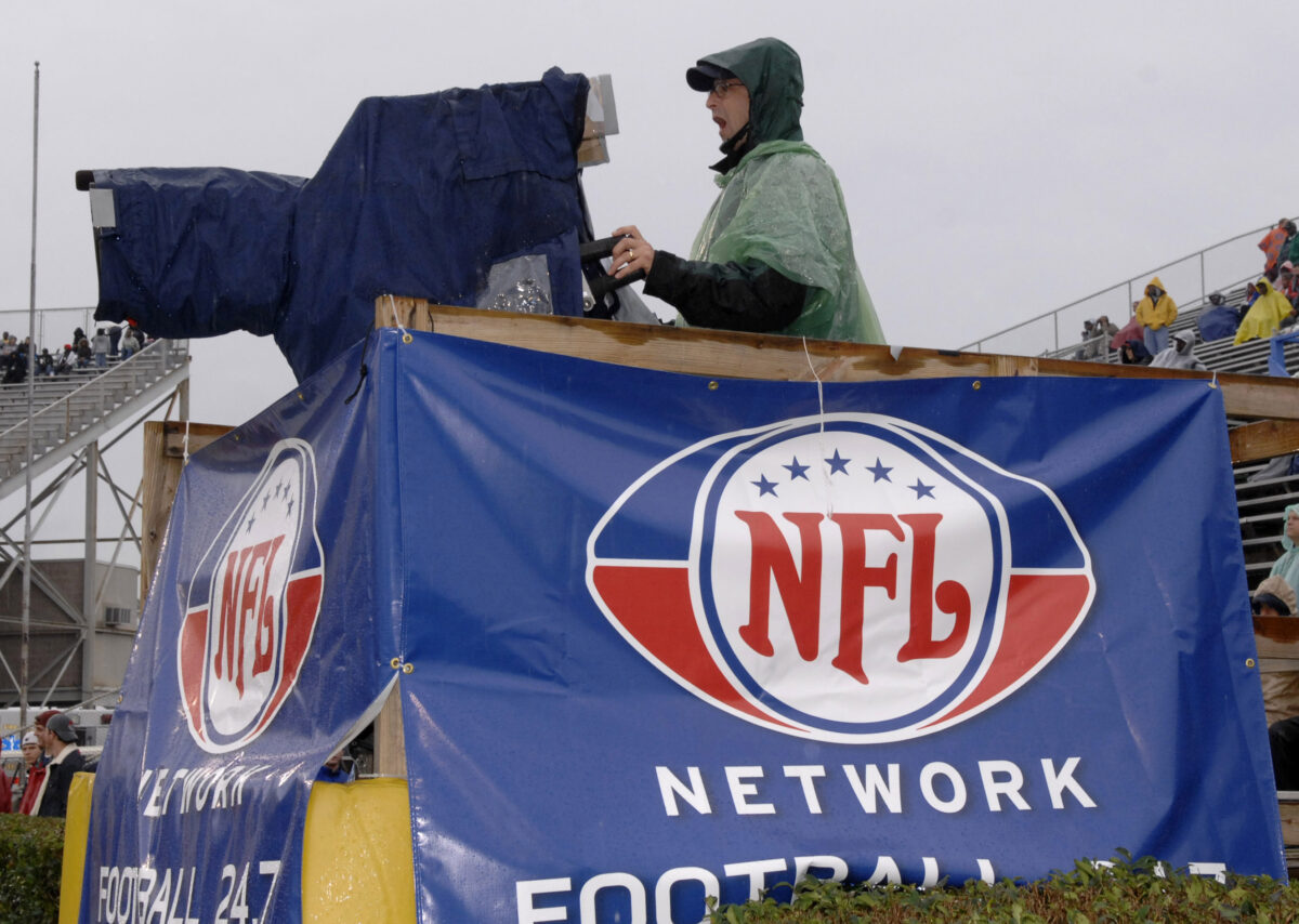
Despite MLB and MLS moving Los Angeles games ahead of Hurricane Hilary, the NFL plans to play Saints-Chargers as scheduled at leaky SoFi Stadium. Bring a poncho:
A tropical storm is set to make landfall in Los Angeles for the first time in 84 years, but NFL commissioner Roger Goodell and other decision-makers in the league office are determined to play Sunday night’s exhibition game on its established schedule, per multiple reports.
So the New Orleans Saints will kick off with the Chargers while Hurricane Hilary barrels up the West Coast, with damaging winds and torrential rain expected to hit the area around SoFi Stadium as early as Sunday evening, per the National Hurricane Center. The exhibition game will be broadcast on NFL Network at 6 p.m. CT/4 p.m. PT, and it’s the only football game on the league’s Sunday schedule.
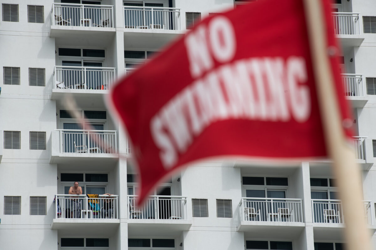
SoFi Stadium does have a roof, but it isn’t a wholly indoor venue. It doesn’t have fully enclosed walls and gaps in the roof have left rain in before. So bring a poncho if you’ve got tickets.
It would have cost the NFL next to nothing to move kickoff up four, five, or six hours to give both teams, officials, fans, and media covering the game more time to prepare for the expected severe weather or evacuate the area. Other pro sports teams like Major League Baseball’s Los Angeles Dodgers and Angels, as well as Major League Soccer’s LAFC and LA Galaxy, decided to reschedule their Sunday games and play double-headers on Saturday.
That wasn’t a viable option for the Saints and Chargers with the Los Angeles Rams scheduled to play at SoFi Stadium on Saturday evening, but the NFL still could have simply moved its kickoff time up a few hours. Instead they risk putting people in danger, and for what? So their panelists can show highlights from Saturday’s preseason games on Sunday afternoon? It’s a bad decision by Goodell and the league office. Hopefully no one gets hurt because of it.
Saints head coach Dennis Allen says the team will join a Friday afternoon conference call with the NFL on their options ahead of Hurricane Hilary:
It’s very rare to see a severe weather systems make landfall in California — but that’s exactly what’s coming, with Hurricane Hilary forecast to make landfall in Los Angeles as early as Sunday night or early Monday morning. Hilary was recognized as a Category 4 hurricane Friday morning though it’s expected to weaken to a tropical storm before reaching Southern California.
That’s becoming a big concern for the New Orleans Saints, who are currently scheduled to kick off with the Chargers at SoFi Stadium. They’re the only game on the NFL’s Sunday slate with a 6:05 p.m. CT/4:05 p.m. PT kickoff.
Saints head coach Dennis Allen shared that it’s something on their radar during his Friday press conference after practice with the Chargers: “I just heard that there’s gonna be a phone call today with the league and stadium, and we’ll see what happens.”
Allen added that the most important concern is for everyone to stay safe. New Orleanians know hurricanes well, and Allen agreed with the oddity of the situation, quipping “Yeah, I guess we brought it with us.”
Allen said representatives from the Saints, Chargers, and SoFi Stadium will join the NFL office in New York for a conference call reviewing their options ahead of Sunday’s preseason game. It would be simple enough to reschedule the game into an earlier broadcast window on Sunday given the lack of potential scheduling conflicts, but the matchup could just as easily be moved to another venue or canceled altogether.
We’ll see what the decision-makers choose to do soon. Stay tuned and, if you’re in the area, make storm preparations now.
With a historic storm approaching Los Angeles and no other games scheduled Sunday, the NFL should move Saints-Chargers into an earlier time slot:
With Hurricane Hilary approaching Los Angeles as a historic storm and no other games scheduled Sunday, the NFL should consider moving this week’s New Orleans Saints preseason matchup with the Los Angeles Chargers into an earlier time slot. Right now the opening kick is set for 6:05 p.m. CT/4:05 p.m. PT at SoFi Stadium in Los Angeles.
The latest forecasts from the National Hurricane Center predict Hilary to reach Los Angeles very early Monday morning — as of Friday, the storm had reached Category 4 status, though its long trek through the mountainous Baja California peninsula and the influence of the cold-water California Current is expected to weaken the system to tropical storm status before it approaches America’s second-largest city.
Still, that’s a very tight window for people to stock up on emergency supplies or consider evacuating. Wind won’t be the primary concern with Hilary, but rain will. Heavy rainfall, flash flooding, and mudslides are likely to challenge local emergency services. Louisianans and communities around the Gulf South are familiar with the threats these tropical storms present, but they’re a rare occurrence in South California. The last system to make landfall in the area was the 1939 Long Beach tropical storm which brought historic flooding, killing dozens of people and dealing out millions of dollars in property damage.
All that said to say this isn’t something to take lightly. If you or a loved one are in the area, make preparations now and follow local guidance accordingly.
And it would be very simple for the NFL to accommodate everyone by rescheduling the Saints-Chargers exhibition game for an earlier broadcast window on Sunday. Sure, it’s a national broadcast on NFL Network — but it’s the only NFL preseason game on the Sunday slate. Every other team plays Thursday, Friday, or Saturday. So it’s not like the league would be giving other matchups less attention by moving the game from its scheduled kickoff time.
Moving kickoff up even three or four hours would make life easier for everyone; not just the players, coaches, and staffers who made the trip from New Orleans, but the thousands of fans who traveled to support them and everyone working the Saints media beat. Not to mention the less stress it would put on local emergency responders and government resources as they prepare for a severe weather event.
Canceling the game altogether is another option, but that’s a tough proposition. Both teams have been preparing for weeks and months for this opportunity. Dozens of jobs are on the line for players on the roster bubble who need this opportunity to impress on a big stage. The Chargers, to their credit, are also managing a fundraiser at the game to support relief efforts in the wake of recent Hawaii wildfires. There’s a middle ground between keeping the game as-scheduled and wiping it out entirely.
We’ll see if the decision-makers at the league office in New York agree. Stay tuned.
A rare West Coast hurricane has been forecast to strike Los Angeles after Sunday’s Saints preseason game. Hurricane Hilary is a Category 1 right now, but it’s rapidly strengthening:
Heavy rainfall from #Hilary may produce flash floods and landslides over parts of Baja California through the weekend. Rainfall impacts in the SW US are expected to peak this weekend into Monday. Flash, urban, and arroyo flooding has the potential for significant local impacts. pic.twitter.com/qzdw6CijhA
Don’t take this lightly. The National Hurricane Center announced Thursday morning that a tropical system off the coast of Mexico is now a Category 1 hurricane, named Hurricane Hilary, with measured sustained winds at 75 miles per hour.
We’re approaching the peak of hurricane season, and many New Orleans Saints fans in Louisiana and across the Gulf South are well-attuned to this dangerous weather threat. Just two years ago the region was struck hard by Hurricane Ida, prompting the Saints to move their entire organization to Dallas so they could finish training camp, kicking off their Week 1 “home” opener at the Jacksonville Jaguars’ stadium instead.
But what’s unusual is that Hurricane Hilary is approaching the West Coast. The NHC forecasts the storm to run up the Baja California peninsula before making landfall in Southern California overnight Monday. Excessive rainfall and potential flooding is predicted for major metro areas in Los Angeles and San Diego, potentially reaching as far inland as Reno, Nev. by Tuesday.
And the Saints are currently in Los Angeles for their preseason game with the Chargers on Sunday at SoFi Stadium. Kickoff is scheduled for 6:05 p.m. CT/4:05 p.m. PT, so the team will have plenty of time to finish their exhibition game and fly back to New Orleans. It could be dicey for fans and media traveling to Los Angeles who aren’t able to immediately leave Sunday evening, though.
The NHC advises that Hurricane Hilary is strengthening rapidly and that it could be upgraded to a major hurricane later Thursday. The storm will weaken after making landfall in Baja California, but to what degree is unclear. If you’re in the area make preparations now and stay tuned for updates from the NHC, local authorities, and emergency services.
West Coast hurricanes are rare. A number of geographic and atmospheric conditions make it difficult for tropical storms to form and sustain themselves, including the powerful cold-water California Current running down from the North Pacific. But they’ve happened before. Los Angeles’ 24-hour rainfall record was set back in Sept. 1939 when a tropical storm dropped more than 5 inches of rain on the area. Last year, Hurricane Kay peaked as a Category 2 before deteriorating after landfall in Baja California, ultimately just grazing the Southern California coast. Hopefully Hurricane Hilary takes a similar track.
Many Florida golf courses suffered in Hurricane Ian, and now comes a potential double whammy with Nicole.
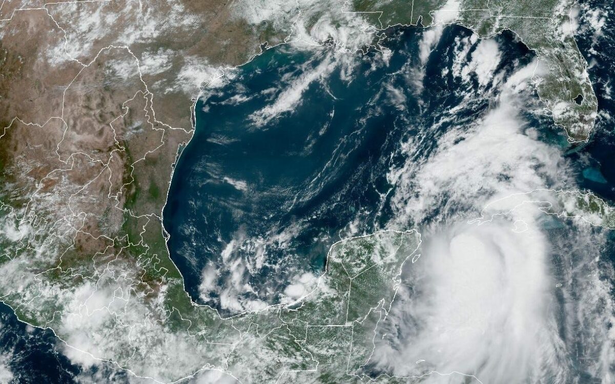
ORLANDO – Tropical Storm Nicole, forecast to become a hurricane before making landfall somewhere Wednesday night or early Thursday morning in South Florida, threatens to bring potentially damaging high winds and heavy rains to hundreds – possibly thousands – of golf courses along the eastern coast of the U.S.
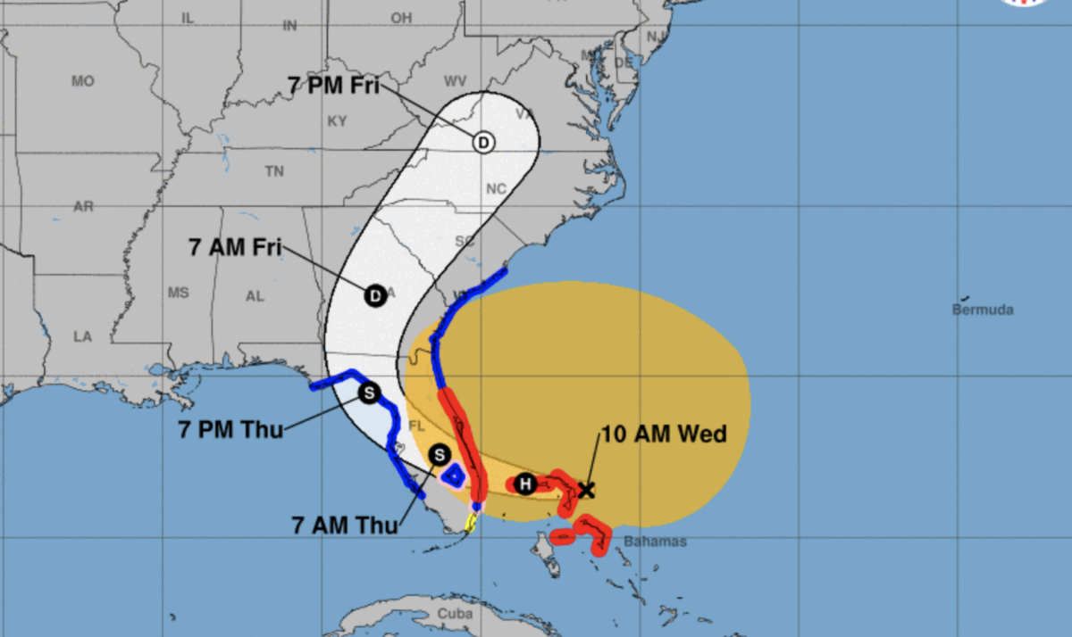
The storm was over the Bahamas on Wednesday morning with sustained winds of 70 mph, according to the National Hurricane Center’s 10 a.m. report. It was forecast to reach the U.S. somewhere just north of West Palm Beach near the golf hot spot of Jupiter, home to many golf professionals. The storm is then forecast to cross Florida toward a region just north of Tampa and into the Gulf of Mexico before curving to the northeast into Georgia.
The storm’s projected path is likely to change slightly, as most tropical systems do, making it difficult to predict exactly which specific areas will be greatly impacted. And while most attention is – and should be – focused on any potential human toll and the threat of general property damage, there definitely will be impacts to a Florida golf industry that already suffered greatly from Hurricane Ian in September.
The National Hurricane Center’s 10 a.m. Wednesday projections for the path of Tropical Storm Nicole, which is forecast to become a hurricane before reaching Florida on Nov. 9 or Nov. 10 (Courtesy of the National Hurricane Center)
While Ian blasted Fort Myers and Florida’s southern Gulf Coast before crossing the state headed northeast, Nicole threatens to head northwest, crossing Ian’s path somewhere south of Orlando. While the greatest damage to golf courses is likely near landfall, there exists a serious threat where this week’s storm crosses paths with Ian’s track, making for a forbidding “X marks the spot” of potential flooding, tree damage and temporary closures in the center of the state.
In all, there are more than 1,200 courses in Florida. Except for those in the Panhandle to the northwest, few Florida course operators will escape some level of impact – ranging from a simple loss of tee time sales all the way to suffering catastrophic damage – from either Ian or Nicole. Because of Florida’s great amount of courses, more than one in 12 courses in all of the United States was impacted just by Ian.
Florida has hundreds of golf courses along Nicole’s projected path. Just among Golfweek’s Best ranking of top public-access courses in Florida, the storm’s landfall could impact PGA National Resort in Palm Beach Gardens and its No. 8-ranked Champion Course (site of the PGA Tour’s Honda Classic each year) as well as the resort’s other courses; PGA Golf Club’s 14th-ranked Wanamaker Course and 21st-ranked Dye Course in Port St. Lucie; Trump National Doral Miami’s Blue Monster (No. 15); Turnberry Isle’s Soffer Course (No. 16) in Aventura; possibly the waterfront Crandon Park (No. 19) at Key Biscayne; and The Breakers’ Rees Jones layout (No. 22) in West Palm Beach.
Among top-ranked private courses in Florida near the projected landfall are No. 1 Seminole in Juno Beach; No. 4 John’s Island Club’s West Course in Vero Beach; No. 5 Indian Creek in Miami Beach; No. 6 The Bear’s Club in Jupiter; No. 9 McArthur in Hobe Sound; No. 10 Loblolly in Hobe Sound; No. 12 Medalist in Hobe Sound; No. 13 Pine Tree in Boynton Beach; No. 14 Trump International in West Palm Beach; No. 16 High Ridge in Lantana; and No. 19 Country Club of Florida in Village of Golf. Those are just the courses ranked in the top 20 among Florida’s private clubs – there are dozens more private courses near projected landfall.
Golf carts at Sanibel Island’s The Dunes Golf & Tennis Club caught fire Sunday, Oct. 16, 2022, several weeks after Hurricane Ian passed by. The Dunes suffered significant damage when Ian slammed in Southwest Florida on Sept. 28. (Photo by Mike Dopslaff/Special to USA Today Network)
As Nicole crosses the Florida peninsula, the projected path takes it just beyond Streamsong Resort, home to three highly ranked courses. As Nicole nears Tampa, it is likely to halt play in this week’s LPGA Pelican Women’s Championship at the private Pelican Golf Club in Belleair near the coast west of Tampa. Just down the street from Pelican is Belleair Country Club, where a major restoration is underway of that club’s Donald Ross-designed West Course. Farther north of Tampa, work is underway on a renovation to the two courses at World Woods, which recently was rebranded as Cabot Citrus Farms.
The storm’s effects already were felt with Wednesday-morning squalls north of the projected path near Orlando, where some courses are still recovering from Ian’s massive rainfall. Some courses in this area are still repairing washed-out bunkers and haven’t completely dried out more than a month after Ian passed not far to the south.
Anyone with golf travel plans this week to Florida should check with their air carrier to see if cancelations are in effect, as several airports in the Sunshine State have closed or will close Wednesday, with potential reopenings yet to be determined. Orlando International Airport announced it will close at 4 p.m. Wednesday, and several regional airports in Central Florida likewise have announced closures. Palm Beach County Airport in South Florida also announced a closure Wednesday morning. Other closures and extended delays are likely around the state.
As Nicole turns north after passing Tampa, its nearly 1,000-mile projected path will take it over central Georgia between Atlanta and Augusta, then into South Carolina and north along the Appalachian Mountains through North Carolina, Virginia, beyond Washington DC and toward New York before passing back into the Atlantic Ocean. With heavy rains likely and severe flooding possible, that projected path will hamper operations and possibly cause damage at more than a thousand golf courses along the way.
Even for golf courses that don’t suffer severe damage from floods, many layouts in year-round golf environments already have begun winterizing efforts, such as spreading rye grass that could be washed away in heavy rains. Results potentially include the expense of reseeding and a downturn in seasonal turf conditioning.
In Florida, the most likely damage will be downed trees and flooding. Many courses along Nicole’s projected path already are suffering from saturated ground in the wake of Ian, making it even more likely that root systems of trees are weakened and trees can topple. Not even counting the dozens of courses that suffered Ian’s greatest damage near Fort Myers, many others are still working to repair bunkers that were wrecked by more than a foot of rain in a 24-hour period – several courses just south of Orlando still have standing water along fairways from Ian.
Most course superintendents along the projected path will spend Wednesday and Thursday readying their courses for the rain and wind, moving loose items and even taking down signage. But there’s only so much that can be done – it’s impossible to board up a whole golf course. The days preceding a hurricane or tropical storm in Florida are always an uncomfortable period of scrambling, waiting, watching weather reports and hoping for the best.
Stage II of Q-School will return to Florida in November.
The LPGA has postponed Stage II of LPGA Q-School due to the impact of Hurricane Ian, a Category 4 storm that slammed into Florida on Sept. 28. Stage II will remain at the Plantation Golf and Country Club’s Bobcat and Panther Courses in Venice, Florida. The dates, however, have been adjusted from Oct. 18-21 to Nov. 17-20.
The LPGA reported in a release that while the club did not endure catastrophic damage, the storm knocked down a significant number of trees and washed out many bunkers. Many Venice area hotels and restaurants face extended closures due to lack of power.
“We are so thankful that our friends at Plantation Golf and Country Club survived the hurricane and are all safe,” said Kathy Lawrence, vice president of Tour Operations and Q-Series. “Now that they have had time to survey the course, we agree that we need to make the difficult decision to postpone Stage II of Q-School.”
Entries for Stage II closed on Aug. 8. The 72-hole tournament will not have a cut. Those who complete 72 holes and do not advance to Q-Series will earn 2023 Epson Tour status. A minimum of top 30 and ties will advance to Q-Series. The final number will be determined prior to the start of competition.
Q-Series, the final stage, takes place over the course of two weeks (Nov. 28-Dec. 11) at Magnolia Grove and Highland Oaks Golf Course in Mobile and Dothan, Alabama, respectively.
“Well, the island is still there … a lot of homes are still standing,” Dopslaff said. “In our case, we took a pretty devastating hit.”
Mike Dopslaff visited the golf course he operates on Sanibel on Wednesday. It was the first time he’d been there since Hurricane Ian pummeled the island on Sept. 28.
He was straightforward when asked about what he witnessed.
“Well, the island is still there … a lot of homes are still standing,” Dopslaff said. “In our case, we took a pretty devastating hit.”
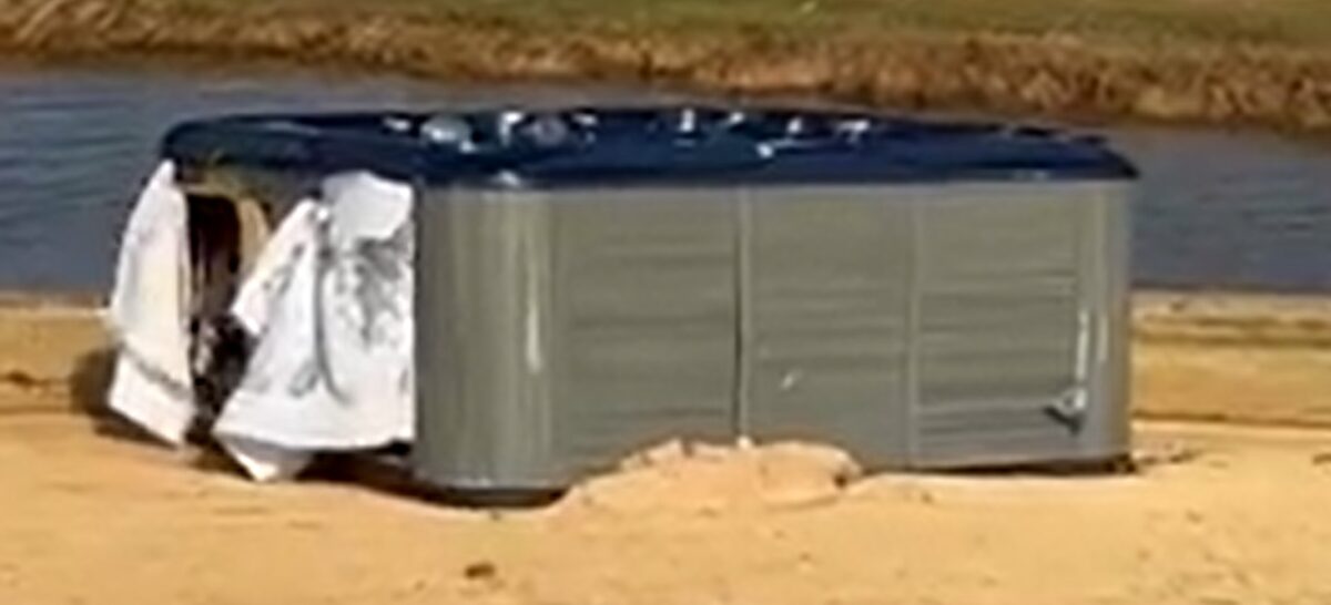
A hot tub ended up on the 18th green at The Dunes on Sanibel Island.
Sanibel is the home of The Dunes Golf & Tennis Club at The Inns of Sanibel. Dopslaff, a Bonita Springs resident, has served as the PGA head professional there for two years. He and his staff have a lot of work ahead of them.
The list is long and includes everything from replacing a damaged fleet of golf carts to understanding what the long-term impact is from the surge of salt water that covered the greens and Bermuda grass fairways.
There’s a good chance it will all need to be replaced.
Damage assessments ongoing
Assessments of the damage will be ongoing, Dopslaff said. He and other members of The Dunes will be returning, by boat, to Sanibel on Friday. There is no access to the island by car or truck after Ian caused five breaches to the Sanibel Causeway.
“Some of our members have docks behind homes and we walked to the club,” said Dopslaff, who is 62. “Ten of us were walking down the street carrying supplies. We just wanted to get a look at what we need to do.”
Besides the potential saltwater damage to the grass, Dopslaff said there are numerous “big beautiful” trees that have been uprooted, similar to what happened during Hurricane Irma in 2017.
Clubhouse, pro shop still stand
The clubhouse still stands.
“To the extent there are walls and a roof still there. We will start tearing out carpet,” he said.
The pro shop is located on the south side of the clubhouse and is where the storm came in from. About eight inches of water came inside.
“And would you believe not a shirt was knocked off of a hanger,” Dopslaff said. “We have some total losses and nice surprises. Our pavilion is still standing.”
Dopslaff said there are approximately 500 members (about 100 play golf) at The Dunes, which also has tennis courts and a swimming pool. The par-70 golf course is 18 holes and measures 5,600 yards from the back tees.
The Dunes is located on the northeast side of the island and strangely enough, based on Ian’s path this was good news. The damage could have been worse.
The Dunes is one of two golf courses on Sanibel. The Sanibel Island Golf Club is the other. Dopslaff has not heard about the damage there. And there is a course on Captiva called The Sanctuary.
Eyes on recovery
Dopslaff understands golf is not something many people are thinking about right now. He said he and his staff and The Dunes organization is committed to helping the island recover as quickly as possible.
“My heart goes out to the residents out there,” he said. “Businesses we rebuild but there are full-time residents with no place to live.”
When the day comes that Sanibel is returned to its pre-Ian state, if that is even possible, Dopslaff is looking forward to that day and especially the good feelings it will bring to him and countless others.
“Once the shock wears off, and the inspiration I will get from bringing it back and overcoming the challenges … it will feel good when we open the doors and have someone teeing off that first tee again,” he said.
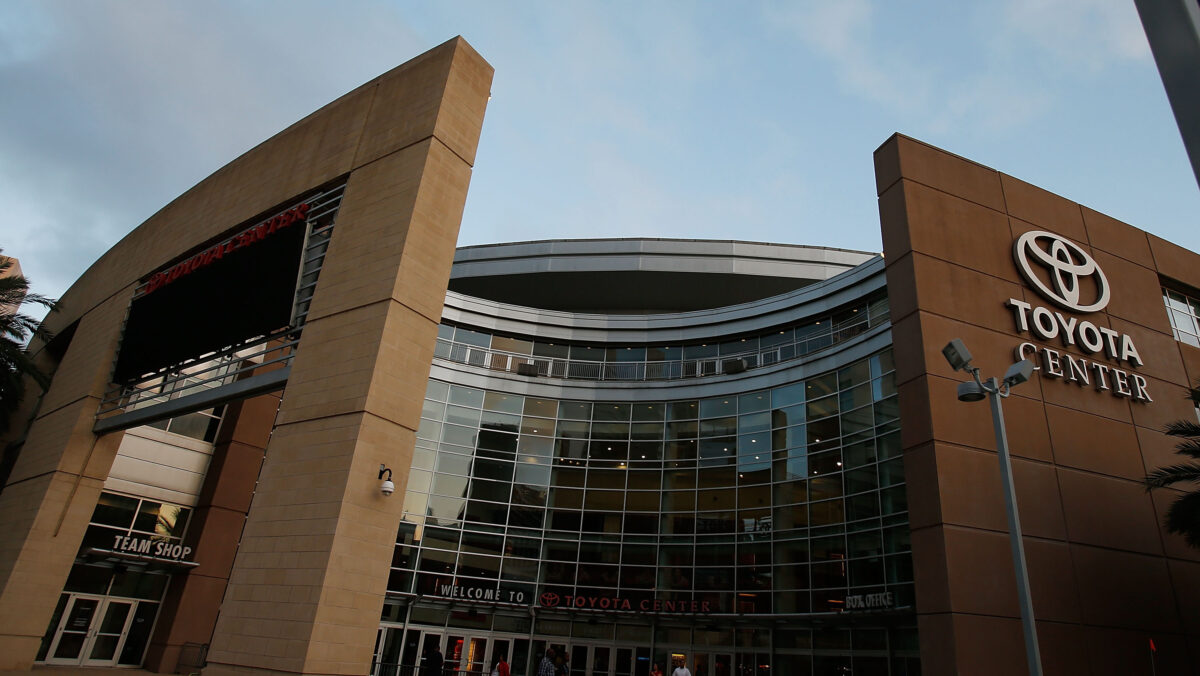
The Fertitta family, Rockets, and Harris County Precinct 1 Constable Alan Rosen are hosting a Hurricane Ian relief drive, and fans who donate at least seven items will get a ticket voucher.
The Houston Rockets, along with the family of team owner Tilman J. Fertitta and Harris County Precinct 1 Constable Alan Rosen, are hosting a relief drive at Toyota Center for victims of Hurricane Ian. Fans who donate at least seven needed items will get a ticket voucher.
Items will be accepted at select times on Friday, Oct. 7 and Saturday, Oct. 8, and the voucher can be used on free tickets for the team’s regular-season game on Monday, Oct. 24 versus Utah.
Here are more details from the team’s announcement, including details on when and where donations are being accepted:
The Fertitta Family, Houston Rockets, and Harris County Precinct 1 Constable Alan Rosen are teaming up to host a relief drive for victims of Hurricane Ian which caused widespread damage last week in the southeast United States.
Donations will be collected curbside at the intersection of Polk and La Branch Streets at Toyota Center on Friday, Oct. 7 from 8 a.m. to 2 p.m. (local time) prior to the Rockets’ preseason game later that night versus Toronto.
Fans attending the Rockets’ annual open practice and fan fest on Saturday, Oct. 8 are also encouraged to donate items when they enter Toyota Center. Information on registering for Saturday’s event, which is open to the public, is available at Rockets.com.
Fans who donate at least seven items will receive a voucher to attend the Rockets game vs. Utah on Monday, Oct. 24. Items needed include water, non-perishable food, baby food, diapers, and cleaning supplies. American Red Cross Texas Gulf Coast is aiding by identifying those in need from impacted areas to distribute the donated items.
Constable Rosen was first elected to his position in 2012 and has three decades of experience in local law enforcement. He established the first homeless outreach team for his department and managed security of the NRG shelter during Hurricane Harvey in August 2017.
Further information on all of these events and activities is available from the team’s official website at Rockets.com.
The NFL has announced its plans to auction off game-worn jerseys from the #Chiefs vs. #Buccaneers Week 4 game to benefit American Red Cross Hurricane Ian relief efforts.
The NFL is doing its part in supporting Floridians in Hurricane Ian relief efforts. Not only will the league match the $1 million contributed by the Buccaneers ownership, but they’re doing something cool surrounding the Week 4 game between the Kansas City Chiefs and Tampa Bay Buccaneers.
The game will be played as scheduled in Raymond James Stadium in Tampa. With it being the only game played in Florida this weekend, the NFL is planning to auction off jerseys worn by Chiefs and Buccaneers players in the game in order to benefit the American Red Cross relief efforts across the state.
Here’s a look at what the league said in their press release:
“Following Sunday night’s Kansas City Chiefs – Tampa Bay Buccaneers game, the NFL will also be auctioning off a limited number of game-worn jerseys and other unique items which fans can bid on at NFL.com/auction to support the American Red Cross’ Hurricane Ian relief efforts. NFL Auction also has several items already listed to bid on to raise funds for hurricane disaster relief.”
If you’re in a position to contribute, you can wait until after the game and bid on a jersey. You can also visit www.redcross.org/nfl or text IAN to 90999 to make a $10 donation and help relief efforts now.